Geo Ordering
Geo Product information
Operative system
Geo Professional supports all Windows versions.
Versions
Geo Professional is built in modules. Base includes basics. When in need of more functions, you upgrade with modules you need. Other modules are Road, Terrain, Net adjustment.
License
Licenses is provided in 3 flavors.
- Hardware lock. Control licenses in a software. Offline capabilities.
- Single network. One user, online license server.
- Multi network, Multi users, online license server.
Geo benefits
- Powerful – Do not require CAD.
- Simple structure, but with many advanced functions.
- User friendly with file based data.
- Productive workflows.
- 30 years of development.
- Used in over 20 countries.
- Translated to several big languages.
- One of the worlds most modern and powerful geodetic software.
- Addon modules for road line, volum calculation, terrain model, tunnel, point cloud and net adjustment make Geo Prefessional to a complete geodetic software.
System recommendation
- Operation system Windows 7 or later
- Processor 2GHz (Intel- eller AMD-compatible)
- Dedicated graphic card for accelerated 3D graphic and separated graphic memory and support for OpenGL 2.1 or later.
For Geo version 2023- must the processor that is used on the computer, support AVX, see Wikipedia
Terrain model
![]() Geo Terrain Model has all the necessary features to create, edit and volume calculate a digital terrain model. Many graphical editing functions for the model, such as creating new triangles, removing triangles, rotating triangles, moving points, editing point heights, connecting and dividing stop lines give you great flexibility.
Geo Terrain Model has all the necessary features to create, edit and volume calculate a digital terrain model. Many graphical editing functions for the model, such as creating new triangles, removing triangles, rotating triangles, moving points, editing point heights, connecting and dividing stop lines give you great flexibility.
Level curves can be created with any equidistance directly from the terrain model. Level curves can also be displayed directly in the model as an aid in editing.
From the terrain model, terrain sections and terrain profiles can also be created.
Volume calculation model-to-model means that volumes can be calculated between two optional models, between a model and a reference level or between the model and its own bottom surface (calculation of piles). The area to be calculated can be limited by a boundary polygon. The results of the calculation are given as excavation and filling volumes and areas. In addition, a difference model can be created in the volume calculation. From this, in turn, excavation and filling planes can be obtained to get a good overview of the location of the excavation and filling masses.
Road line
![]() Geo Road Lines lets you use everything from simple line calculations to more advanced 3D features for full control of your road, rail or management projects.
Geo Road Lines lets you use everything from simple line calculations to more advanced 3D features for full control of your road, rail or management projects.
Here you can easily calculate and create all the plan data, profiles and distortions needed to describe the line in three dimensions, using the powerful graphical and numerical tools.
When the line data is connected to a three-dimensional object, coordinates in three dimensions can be easily calculated for any position along the path. This means that a control of a road can be performed quickly and efficiently.
SAK – Statistical acceptance control, the standard that must be used in all road construction according to VÄG94, has been developed to meet all requirements from contractors and customers. Of course with detailed reports to facilitate the documentation of the inspection.
Volume calculation with section
![]() Geo Volume Calculation has all the necessary functions to create, edit and volume calculate a complete road or railway.
Geo Volume Calculation has all the necessary functions to create, edit and volume calculate a complete road or railway.
With normal sections, side lines, terrain models and sections, road lines, profiles, skews, different layers and superstructures, you build up the current object. To facilitate and simplify, most of the work is done graphically. Output data can be taken directly from terrain models, saturated lines or terrain sections.
In the mass description, fill in all current parameters. It is possible to have up to five different layer types, several different terrain models per layer, borders, swelling factors, topsoil removal and more. An unlimited number of standard sections, with or without interpolation between them, may be included. The standard section can describe all existing roads and railways with all its elements.
As a result of the volume calculation, you get a detailed quantity report that you compose yourself, as well as a file with complete section data that can be drawn out to give a more comprehensive account of your mass calculation.
Note that this module requires the road line and terrain model module to function.
Tunnel
![]() Geo Tunnel module gives you total control over the tunnel. With a tunnel model and extensive volume calculation, unlimited possibilities are given for accounting and control of tunnels in all forms.
Geo Tunnel module gives you total control over the tunnel. With a tunnel model and extensive volume calculation, unlimited possibilities are given for accounting and control of tunnels in all forms.
The design of theoretical tunnels is done easily with graphic and numerical aids. Any number of theoretical tunnel sections are connected with or without interpolation. Together with a road line and a profile, a complete description of the tunnel is formed in three dimensions.
Volume calculation can be done against a theoretical tunnel with optional offset, and is limited in side and height. A volume report, together with the extensive drawing functions, provides a detailed account and control of the tunnel.
A measured tunnel can be directly compared with a theoretical tunnel, with an account of the section, side dimensions and distance from the theoretical tunnel, for quick control of critical sections. It is possible to calculate different models and report at the same time as different layers.
Measurement of tunnels is most conveniently done with the field computer GeoPad and Leica or Trimble / Geodimeter servo instruments with prismless distance measurement.
In GeoPad you can control the tunnel measurement in all dimensions. Any interval between measured sections and any interval along the section can be specified. In addition, you decide which part of the tunnel, lengthwise, heightwise and sideways, is to be measured. There are also functions for loading and managing data from tunnel scanning.
Net adjustment
![]() Geo Net adjustment allows you to calculate small and large networks easily and with a good overview. The size of the network is limited only by the performance of the computer.
Geo Net adjustment allows you to calculate small and large networks easily and with a good overview. The size of the network is limited only by the performance of the computer.
The graphical user interface makes it easy to plan the design of the network directly in the map image together with the background image and analyze the expected accuracy and reliability long before a single measurement has been made.
Troubleshooting is facilitated by color coding of control values and you can activate and deactivate measurements directly in the graphics and find the best solution. The calculation is performed with the least squares method and all weighting is done according to HMK’s guidelines. For the calculation of the backbone network for railways, it is also possible to choose weighting according to the BVH test quota as an alternative to standardized residuals. Connection to a known network can take place in several different ways, completely fixed, free or with a certain mobility in the connection points based on previously known accuracy.
The calculation is reported in a comprehensive report with statistics, measurement values and quality measures.
Point cloud
![]() (This module is updated with new engine, new fast format (hspc) and new functions, from 2022)
(This module is updated with new engine, new fast format (hspc) and new functions, from 2022)
This module Punktmoln is the module for you who somehow handle large amounts of data and need a tool to rationally manage these in Geo.
Geo uses a very powerful database that indexes the points for fast data access, the point cloud module handles very large datasets and renders up to 8 million points on the screen.
Geo supports a number of common scan formats such as LAS, PTS, E57 and more. ESRI grid files that Lantmäteriet uses for the national altitude model can also be handled with Geo point clouds. Leica’s multistation MS60 is also supported in the program.
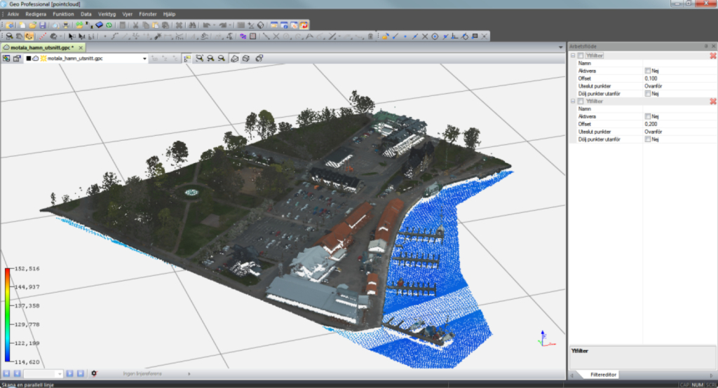
Geo point clouds have advanced filter functions to quickly and rationally clean out unwanted data such as trees, buildings and other noise.
Tools for finding the lowest or highest points in a grid to easily make a terrain model that can be saved and used in the usual way or used to filter out unwanted data. After filtering out irrelevant data, you can easily export your filtered point cloud to any of the following formats:
*.las, *.geo, * .pts, * .dwg
Point Database
(The module is upgraded to work easier with Microsoft SQL and with 64-bit Geo from 2022)
The module for point database makes it possible to connect Geo to a general ODBC-compatible database, for example Oracle-based database applications from Tekis (Topobase) or from Spatial Technology.
It is possible to make advanced searches of points by setting up combined search criteria. You can also use your own SQL statements. It is also possible to use boundary polygons to control the set of points. The database queries can be saved, which makes it easy to retrieve the same point selection at different times.
The database connection can be configured so that optional columns from a table or view can be displayed in Geo. The points can be displayed both graphically and numerically.
In addition to retrieving data, it is also possible to add, edit and delete items in the database. These operations assume that the points are in a certain database table.
It is very easy to transfer points between the database and coordinate files. In measurement calculations, e.g. coordinate calculation, the point database can be used as a source for known points.
Upgrade from Map Base to Topobase The point database module replaces the link to older Map Base versions in Geo. When renewing Geo subscriptions, we replace existing Map Base modules with Point Database modules. The price for this is the same as for renewing other modules.
Trench
Geo Trench, has all the necessary functions to create, edit and volume calculate trenches.
Using the coordinate line (polyline) and terrain models, you build up the current object. To simplify and facilitate, the construction takes place in the first stage with the help of a wizard, where you describe how the conduit should be designed.
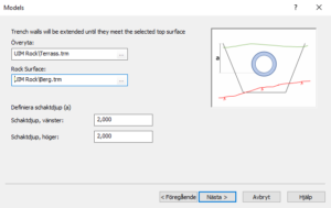
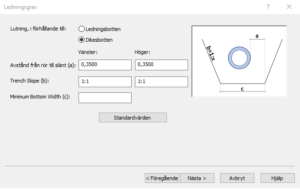
When you have finished the wizard, you come to our classic view with trees, numeric and graphics. Here you can insert several wires and adjust the design of the grave. Determine the thicknesses of the different embankments, how rocks are calculated, the design of peaks, change the dimensions of wells and pipes.
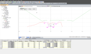
As a result from the Trench, you get a detailed quantity report that you compose yourself, as well as a file with complete section data that can be drawn to provide a more comprehensive account of your mass calculation, excavation models that you can export to excavators and release data to the measurement engineer.